
Formatting the Block Model
Highlights
Accurate formatting of block model data is essential for effective mine planning and optimization. It ensures that all relevant geological and economic variables are correctly interpreted by the software, enabling reliable and actionable results.
- MiningMath requires block model data in CSV format with consistent block sizes and no air blocks.
- MiningMath supports flexible field types and internal calculations, including derived fields. This fosters faster iteration and more informed decision-making for maximizing mine profitability.
The following formatting specifications are required:
Regularized block model: This means all blocks must be the same size.
Air blocks must be removed prior to importation. This is the way MiningMath recognizes the topography.
Coordinates of each block in the 3 dimensions.
Header Names should not have special characters or have them exceed 13. Use this recommendation for folders and files also.
The data format should be a CSV file (Comma Separated Value), which might be compatible with most mining packages.
Example
MiningMath comes preinstalled with the Marvin dataset. Download this file here.
Good practices
- Configure Microsoft Windows number formatting to use dot as the decimal separator.
MiningMath does not recognize CSV’s using semicolon (;) as a decimal separator. You may need to change your Windows configuration, by following these steps:
1. Click Start, type control and click to open Control Panel.

2. Under Clock and Region, click Change data, time, or number formats.

3. Click Additional Settings…, and then we can manually change the Decimal symbol.
Finally, you will need to change the separator on the CSV. On Excel, you will need to open it, convert text to columns, and then save it again.
- Use the metric system. More infor about data in the imperial system can be seen here.
- Set multiple fields that will consider different economic values, material types, contaminant limits, and any other variable you wish to analyze or control.
- Some mining packages export data with letters and values between quotation marks(“”), check if this kind of format is interfering in the importation process.
- If all your values are in the same column, try using the “Text to Columns” option in Excel. This will allow you to break down all the columns using the comma (,) as the correct separator.
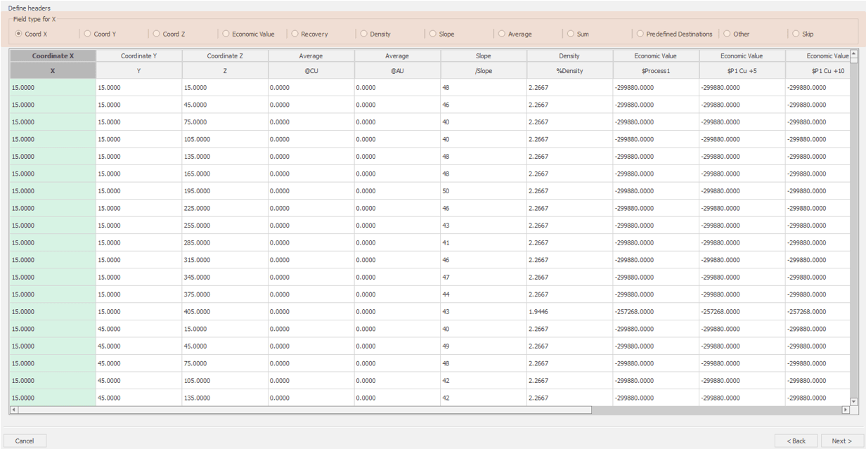
Understanding field types
Field Types are the fields MiningMath can understand. Each column imported should be assigned to the proper field type (as depicted below) so that the software treats each variable accordingly with its meaning.
Mandatory field types and their meanings
Coordinates X, Y, and Z refer to your geo-referenced information.
Average refers to any variable that could be controlled by means of minimums and maximums considering its average: grades, haulage distance, and other variables.
There should be at least one element assigned as Average.
Optional field types and their meanings
Economic Value refers to the columns containing economic data that represent the available destinations for material allocation. To execute a scenario, the model must include at least one process destination and one waste destination.
It is possible to import multiple economic values at once, and they may be used simultaneously (ex.: multiple processing streams) or calculated in the internal calculator.
Density refers to the block's density. This field is used to calculate the block's tonnage.
Slope refers to slopes varying block-by-block, which gives the flexibility to define slopes by lithotype and sectors.
Recovery refers to recoveries varying block-by-block.
Sum refers to any variable that could be controlled by means of minimums and maximums considering its sum.
Predefined destinations refers to possible fixed destination values. This can be used if you want to define pushbacks or apply lithologic restrictions that prevent certain blocks to be processed. However, by fixing destinations you are impeding MiningMath to reach its full potential. More about this here.
Other refers to information that you with to have in the exported outputs.
Skip refers to any variable that should be ignored. This field type might help improving the runtime since these variables will not be considered and exported along with the optimization outputs.
Field names shortcut
Shortcuts can be used for automatic recognition in the importation process as in the following image:

The full list of shortcuts is listed below.
| Field name | Shortcuts |
|---|---|
Coordinates | X | Y | Z |
Average | @ | grade |
Density | % | dens | sg |
Economic value | $ | dest | val |
Recovery | * | recov |
Slope | / | slope |
Sum | + |
Skip | ! |
Formatting conventions
Each software has unique conventions for data formats, naming, and numbering systems. To prevent conflicts when transferring data between different software, ensure you follow the specific procedures required by each. There’s no universal standard—just the correct approach for each tool.
MiningMath convention
The model’s origin must be placed at the bottom portion, starting to count from the minimum coordinates at X, Y, and Z.
The following image highlights a block model origin at the corner of the first block and the coordinates on its centroid.
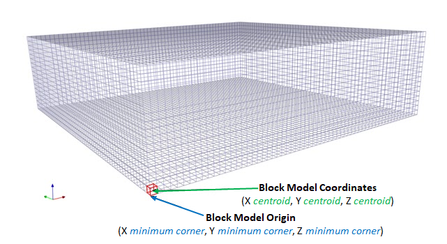
MiningMath uses coordinates (X,Y,Z) for which Z, which represents the elevation, starts upwards.

Other mining packages
Other mining software may use indexes with IZ starting downwards. MineSight is an example that uses this notation.
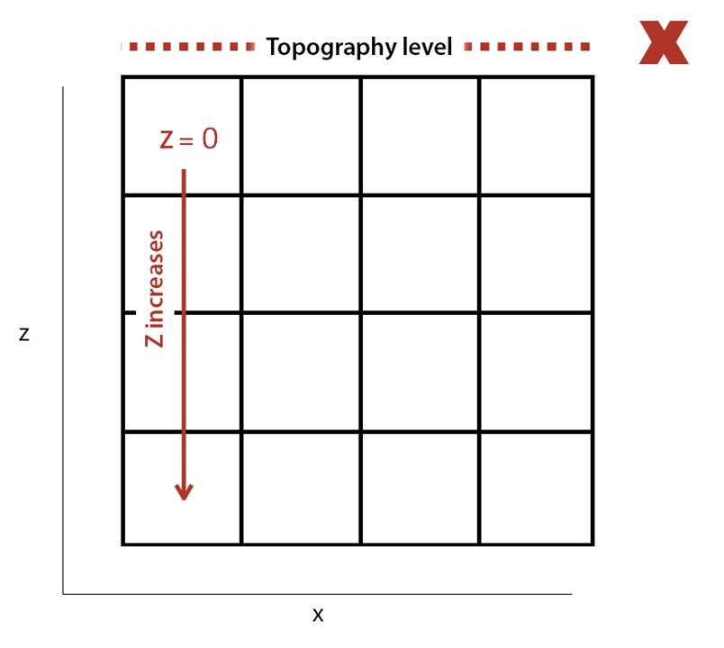
To invert coordinates in this format use the following formula to convert:
\(new(Z) = max(Z) + 1 – current(Z)\)
Good practices
- Verify Coordinate Ranges: Check the minimum and maximum values for each coordinate (X, Y, and Z) in your CSV file to ensure they fit within the box of your block model.
- Set the Correct Origin: The origin of your block model must be set to the minimum values (minX, minY, minZ) of the box. Ensure all block centroid coordinates in your CSV are greater than these origin values.
- Calculate Origins Accurately: If all blocks in your CSV are below the topography, calculate the origin by subtracting half a block size from the minimum value of each axis.
Avoid Common Errors:
1) Ensure the coordinates align with the block dimensions relative to the set origin.
2) Avoid repeated coordinates in the CSV file to prevent import failures.
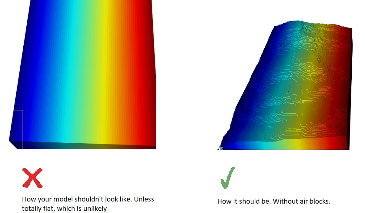
Air blocks
MiningMath recognizes that all imported blocks of your model are underground. This means it is necessary to remove all the air blocks prior to importation. Unless your topography is totally flat, which is unlikely, the image below shows an example of your model should be displayed.
The non-removal of air blocks may lead to unsatisfactory results and long processing times, since it would be considering blocks that do not exist in reality.
More details on air blocks
The following video shows how to do remove air blocks using filters on MS Excel. These tips are also applicable to any mining software of your choice.
